
1. This is the best view of the quarter-of-a-mile-in-diameter Avebury henge without taking to the sky! Avebury’s great bank curves in front of the trees and extends beyond the houses to create an arena with two stone circles, a geometric outer ring, and a cove.
The bank was twice as tall when first built and was pure white, like the chalk pathway along the top. The 30-foot-deep internal ditch, from which chalk was extracted to construct the bank, is not visible in this picture. The presence of a bank surrounding a ditch classifies Avebury as a henge, indicating that it was not built for defence.
A stone beneath the tree on the left marks the beginning of the moon-aligned West Kennet Avenue, which connects Avebury to its Sanctuary, a mile and a half away. Further to the left is the southern causeway that cuts through the bank and ditch. Some of Avebury’s great monoliths can be seen through this gap, even though they look like headstones from this distance.

2. Avebury’s encircling ditch went 30 feet down to the water table. Here, we also see the southern causeway, an exit where West Kennet Avenue once led to Avebury's Sanctuary one and a half miles away. Some of the remaining monoliths of the outer circuit are seen circumventing the ditch, while a few from the southern circle are positioned further back.
A stone plinth that resembles a broken stump is located nearby. This plinth once supported a diagnostic monolith described by Dr William Stukeley as "A stone with a hole wrought through it for tethering horses." However, the holed stone meant something entirely different to Avebury’s early residents.

3. AVEBURY HENGE, NEOLITHIC WOMB.
This image is dedicated to those who thought I could be silenced by infecting my computer with a virus. Also to their college(ies), who turned up to delete my photos of the moon's December 2025 Major Standstill as it rose over Woodhenge. --- SAD.
Avebury, a picturesque village in Wiltshire, is home to Britain's largest stone circle or ring. The remains of that circle is highlighted in yellow. This complex geometric ring is based on Pythagorean triangles and was explicitly crafted to incorporate a vast 750-megalithic-yard-radius arc designed to function as an antenna perfectly aligned with the northernmost rising moon. The awe-inspiring secret to creating such a large radius lies in the ancient geometry developed almost five thousand years ago on Windmill Hill. The majestic Windmill Hill overlooks Avebury from one mile to its northwest.
Early folks were attracted to Avebury's chalkland and used it as a whiteboard to practice their beloved geometry. This geometry was designed to bring the sun, the moon and a star or stars together in various attempts to avoid their harsh winters when nothing would grow.
The geometry of Avebury's outer circuit of stones is mainly due to Professor Alexander Thom's extensive survey of Avebury, assisted by Brigadier A. Prain and Miss E. M. Pickard. "Megalithic Sites in Britain" Oxford University Press 1967.
Thom showed that the geometry of the outer circuit was based on a 3:4:5 triangle but overlooked a second triangle or, more likely, ignored it. We have coloured this second triangle green. You will not learn about this second triangle from anywhere else but here!
Aerial photographs of Avebury are now available on Google Earth and Bing Maps. These images show the precise positions of Avebury's megaliths and concrete plinths that have replaced the missing stones. However, the vertical alignment of Google's image was slightly off and required a minor correction. So, the image was adjusted to match Thom's surveyed measurements between Stone16 and 68 and Stone1 and 50. This method enabled a scaling down of the internal stone settings rather than scaling them up; archaeologists typically use a less accurate approach.
According to the C.A.D. (computer-aided design) analysis, Thom's survey had no significant issues. However, some minor adjustments were made by moving certain circles a small amount to align with the actual positions of the stones. This indicates the need for a modern GPS survey to be conducted. Additionally, since the Avebury Womb is an internal device, measurements should be taken against the inside surfaces of the stones rather than their centres, as Alexander Thom had done.

4. Avebury's north and south circles as Logic dictates.
There are times in life when things feel right. That is how Avebury’s early inhabitants felt when discovering the reversible geometry of this complementary pair. They are opposites, just like male and female!
The Ordinance Survey looked for depressions and fiery pits over which many of Avebury’s stones were felled in preparation for their destruction by heat shock and mallet. So, the OS survey did not show where the stones once stood. The OS plot is, therefore, only valuable for suggesting that the internal circles, north and south, are anything but circular. And it might be years, if ever before archaeologists prove that the northern and southern rings are egg-shaped,
These eggs are a variation on a theme. Both are based on the same three-times-size 3:4:5 triangle but are orientated in diverse ways.
Dr William Stukeley named Avebury's northern egg "A Lunar Temple" - which we now take to mean female - after witnessing the cylindrical Obelisk's destruction at the centre of Avebury's Southern Egg. The Obelisk was phallic and male, as seen from one of Stukeley's drawings. But these were puritanical times in 1720, so Stukeley had the temerity to keep quiet about it!
The Avebury Womb was built to give birth to a boy and a girl. But these were not human but astronomical ........ A Sun and a Moon.

5. A 2021 survey of Avebury’s Cove. This cove can be found in the middle of Stukeley's "Lunar Temple."
This picture of Avebury's main cove is shown along with a couple of stones that remain of its Northern Circle - one stone at the extreme left and the other at the extreme right.
The Cove once consisted of three large stones, or megaliths, arranged in a ‘U’ shape, like an open-sided box.
Covestone 2, in the middle of the picture, is often called the 'Backstone.' Archaeologists believe this stone was placed upright around five thousand years ago and is the earliest and most prominent on the site.
Covestone 1 is the slim stone to the right of the Backstone.
The missing Covestone 3, which once stood to the left of the Backstone, had fallen or was pulled down in 1716 and smashed to pieces before being whisked away for other purposes by Avebury’s villagers in 1720. Dr William Stukeley described Covestone 3 as similar in size and appearance to Covestone 1.
Opinions have varied on the Cove’s astronomical alignment. Some have claimed that it opens out towards the summer solstice of the sun. Others say it aims at the northernmost moonrises every nineteen years. Such confusion prompted me to make several visits to the Cove to make more sense of it.

6. My first survey, published in “Stonehenge Secrets 2007," showed that its two remaining stones are precisely 90 degrees apart. This photograph shows my 90-degree triangle of string, which I placed between Covestone 1 and the Backstone as proof.

7. Mid-summer sunrise at Avebury's Main Cove in 2009.
White tapes were placed against the sides of Covestone 1 and parallel to the Cove’s axis. Also, a few menus from the Red Lion pub were parallel to it, although their contribution to the research was minimal.
With all necessary preparations in place - tapes and menus and camera poised for action - the Druid and I eagerly awaited the sun's ascent.
I got the photograph I wanted and put it on the front cover of a leaflet, which I produced and presented to the six major libraries in 2010, “The Real Avebury” ISBN 978-0-95533012-6-1.
Rewrite 9th November 2025. "Photos of the moon taken during this year's Major Standstill show that Avebury's Cove aims at the moon." I apologise for my earlier mistakes.
8. This photo was taken shortly after the solstice sunrise in 2009 and from a different position. This and the following picture show that Avebury folk were more interested in what takes place a short while after the sun has risen.
These findings have profound implications for other monuments, too, particularly Stonehenge.

9. The inner face of Covestone 2 -- The “Backstone,” shortly after sunrise.
I had my solstice photograph and was about to leave when the druid called me over. “You are missing the best bit,” he cried. “Come over here and look at this.”
“What am I looking for?” I inquired.
“Never mind that -- you just keep clicking away at that camera.”
And so, I did.
Early folks had not altered this stone by flattening and polishing it, but it hardly matters because a few minutes after sunrise, when the sun escapes the earth's atmosphere, it gives off a beautiful rosy-red glow that no one should miss. Imagine what it would look like if cleaned free of lichen to expose myriads of brightly sparkling quartz crystals in its structure!
Avebury folks used this stone as a mirror to join the sun and moon in “Astronomical Intercourse."
*****
Several excavations around the bases of the Cove’s remaining sarsens have been performed over the years. But the deepest was made in 2003 when ripe-husk-free barley seed was found against the base of the Backstone's outer face. Neolithic folks had placed those seeds knowing they possessed the essence of life. Depositing them at the base of the Backstone displays a wish for the Backstone to grow.

10. Never mind the lichen. If a stone would benefit from a good scrubbing, this one would!
Few things archaeological can be proved beyond doubt. The alignment of Avebury's Cove is one of the exceptions. That is why I made another visit on the 20th of September 2021, with a crude Tee-square and affixed compass, to reaffirm the alignment I had found in 2009. It did. The compass showed the azimuth of the Backstone to be about 48 degrees.

11. The Tee-square proved the inner face of the Backstone to have a slight convex bow. It was, therefore, placed in the middle of the stone to give an average result.
The bulbous stone on the left is one of the few remaining members of the Northern Circle, otherwise known as Stukeley's Lunar Temple. It is female, as no doubt was the whole Northern Circle and every stone in it.
Moreover, while describing stone rings as circles is convenient, eggs have an axis and a "pointy end." The axis and pointed end of Avebury's northern egg look towards the equinox, where the setting sun and moon slide down the side of the beautiful Cherhill Hill.

12. Taken at Avebury's Cove shortly after 10 PM on Saturday, 13 September 2025.
With two degrees further north to go, which is to the left in this picture, this is not quite at the moon's major standstill, but near enough.
The camera was initially positioned as shown in picture 7. Fortunately, we soon realised the moon was hidden behind the stone, so we shifted the camera a few feet to the left. Nonetheless, we now had everything needed to prove that Avebury's Cove is moon-aligned. Someone advised me of this some time ago, but I do not remember who or how they knew.

13. Archaeologists' ground plan of Avebury's Cove. REF: Archaeological excavations at the Cove, 2003.
Serving more to confuse than to inform, this plan achieves nothing. The five-metre scale is utterly unreliable, and the north arrow is 30 degrees off. And all of this to deceive you and me. But don't blame the young archaeologists who created it and are under the control of an authoritative regime. Blame the entire sorry state of Stonehenge archaeology today.
“Archaeology in Britain is a shambles from top to bottom.” The late Professor Mick Aston of the Time Team.
Mick was the only archaeologist to speak out against his beloved profession, but he did not live to enjoy his retirement. Here we have another archaeological Red Herring, designed to mislead honest researchers. It also doesn't bode well when trying to explain Avebury's second cove, which lies in Longstone's field close to the village of Beckhampton. The Longstone's Cove, or what remains of it, lies beside the prehistoric Beckhampton Avenue of stones, which once entered the Avebury henge via its western causeway.
******
Avebury's henge has long been known to be an internal device... 'I observed further that as these stones generally have a rough and a smoother side, they took care to place the most sightly side of the stone inward, towards the included area.' Avebury, a temple to the British Druids. Stukeley W, 1727.
Professor Atkinson said the same thing about Stonehenge...'The main concern of the builders was to produce a presentable finish on those surfaces which would be seen from the interior of the site - the exception being the great trilithon.' Stonehenge, page 121. Atkinson R, 1956.
A recent archaeological entry in Wikipedia concurs with Stukeley and Atkinson.
The conclusion is that Avebury and Stonehenge are internal devices.
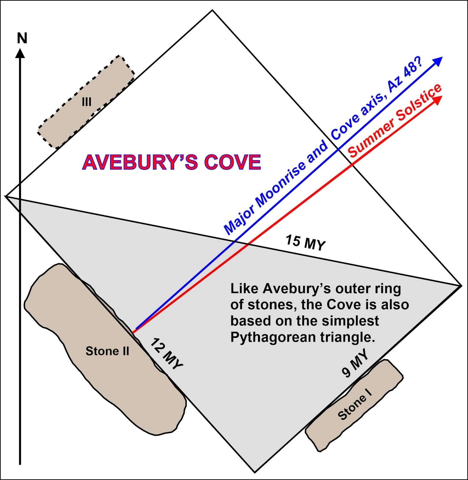
14. Avebury's Cove. These triangles are proportional to 3:4:5 - the most basic Pythagorean triangles.
Having established that the Cove in the middle of Avebury's Northern stone egg is rectangular, we next wanted to know the distance between Covestone 1 and the extant Covestone 3, without resorting to an archaeological excavation to determine the position of the hole where Covestone 3 once stood. Fortunately, we only had to estimate this distance to the nearest Megalithic Yard (32.664 imperial inches / 0.83 metres).
Our T-square was set on the grass and, once more, placed against the inner face of the Backstone. With the help of a friendly day-tripper from Dudley, we, by common consent, positioned the T-square in the middle of the stone. A measurement was then taken from the inner face of Covestone 1 to the T-square, sixteen feet six inches. This figure was doubled to obtain a distance between Covestones 1 and 3 of thirty-three feet, which converts to 12 Megalithic Yards.
Next, we estimated the distance from the inner face of the Backstone to the centre of Covestone 1. This was four megalithic yards, which, when doubled, gave eight in total.
These rough measurements suggest that Avebury's Cove is likely based on a nine-by-twelve megalithic yard rectangle.
Several 3:4:5 triangles could be superimposed on the cove's geometry, as if growing exponentially — like a child.
*****
Avebury’s Cove is akin to baking a cake. Apart from numerics and Pythagorean triangles, which are known to represent the family with their three sides, other ingredients are --- barley and wheat seeds, which hold life in dormancy until fertilised by the sun and rain, semen, infant burials, and other unknown materials.
Professor Alexander Thom must be congratulated for resolving the geometry of Avebury’s outer ring of megaliths while dealing with its axis of 42 degrees clockwise from the north, for this was no easy task.
However, Thom failed to find the second 30:40:50 triangle and the 250 MY radius cast from its corner F.
Thom did believe in a second triangle, though, and had he found it -- or deliberately overlooked it -- he'd have known it led to many more, as is demonstrated by the mass of Pythagorean triangles inscribed on a sheet of gold-coloured paper, shown next.

15. The geometry that Avebury's outer circuit of stones is based on.
Avebury’s early residents recognised the large number of 3:4:5 triangles that made up the rectangle shown above. They probably produced it on a gold sheet measuring seven-and-a-half by ten megalithic inches, as the Stonehengers did when they made their nine-megalithic-inch-long gold lozenge, which they placed across the chest of the Bush Barrow Man as he was buried in a round barrow to the south of Stonehenge.
The above geometry is another reason Avebury was such a popular venue, drawing people from miles around to help build the outer circuit of some ninety-eight stones.

16. This is how Professor Thom applied the theory of cords to find the actual radius of Avebury's large moon-aligned arc. However, this is not how Avebury's early inhabitants achieved it: they derived it from early geometrical experiments carried out on top of Windmill Hill.
The basic theory of chords states that A squared will always equal B times C, regardless of where the vertical chord is placed.
The middle circle demonstrates this by showing what occurs when the vertical is shifted 25 units to the left of the centre. Unfortunately, A now requires many decimal places to maintain accuracy. However, overly long figures are unnecessary, since they are the square root of B multiplied by A and are quickly calculated on a modern calculator.
Professor Thom extended Avebury's massive 750 megalithic yard arc beyond the limits of its stones to show it could stand off a 1500 circle by 10 megalithic yards.

17. Moel ty Ucha: From "Megalithic sites in Britain" by A Thom. Llandrillo, Bala, Wales.
Moel ty Ucha is based on two pentagons.
This is another of Professor Thom's many surveys that deliberately misleads us by plotting the geometry through the centre of the stones when it should be plotted internally. The correct geometry is shaded in grey.
More corrected geometries can be found throughout this site and our sister site, StonehengeOlogy.com.

18. Kerry Pole stone circle, near Newton Pow, Wales. From "Megalithic Sites in Britain" by A Thom.
To reiterate: Professor Alexander Thom drew geometry passing through the centre of the stones when he should have worked on their inside faces. This was common with Thom and it was incorrect.
So far, I have corrected eight of the most important and will slot them into convenient positions as I have with the pair above.
Kelly Pole appreciates the simplest of Pythagorean triangles, 3, 4, and 5, but in linear form, with circle centre spacings of 3, 4, and 5.- Clever.
Furthermore, it has what Professor Thom called "corners" when referring to his survey of Avebury's outer ring.

19. HIRNANT EGG-SHAPED RING CAIRN, MID-WALES.
From Megalithic Remains in Britain and Brittany by A. Thom and A. S. Thom, page 21. Clarendon Press. Oxford 1978.
The geometry underlying Hirnant proved especially challenging to decipher because most measurements are in Megalithic Inches. However, a single measurement of 141.5 Mi further subdivides the Megalithic Inch to define a "Yard" of 80 parts.